Why the Mid Kettle Moraine?
|
Ten thousand years ago, the last continental glaciers receded from what is today Wisconsin, leaving behind a landscape of long braided ridges, rounded hills, potholes, lakes and wetlands — the area we now call the Kettle Moraine. The glaciers bestowed on Wisconsin a beautiful and rare landscape that stretches 135 miles south-southwest from Manitowoc County almost to Illinois.
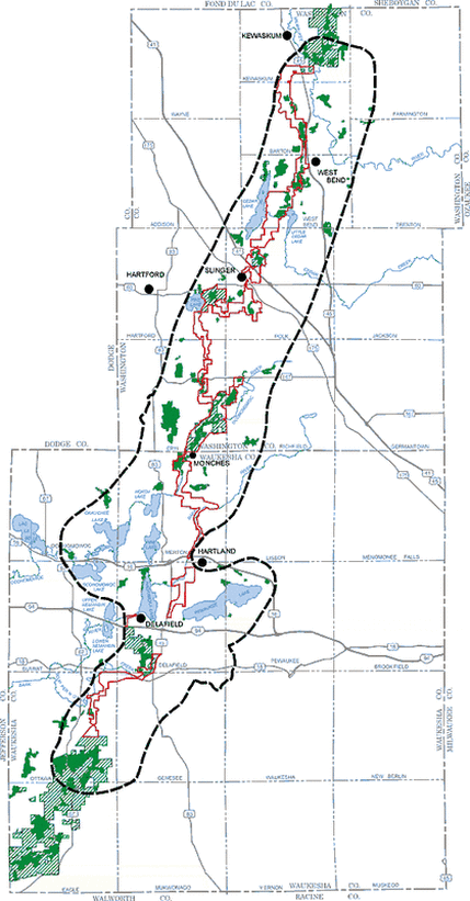
The features of the Kettle Moraine were formed by the advance and retreat of two glacial lobes, one lying in Lake Michigan to the east, the other having scoured out Green Bay, Lake Winnebago and Horicon Marsh to the west. As the glacier ice advanced for thousands of years, it picked up boulders, sand, gravel and clay. As the ice gradually thawed, these materials were deposited between the two glacial lobes. Kettle ponds formed when large blocks of ice fell from the face of the glacier, were buried by the deposits and then melted over a period of years. As the climate gradually warmed, the Kettle Moraine grew forests. Today, bur oak and prairie plants dominate in the south, while sugar maple and red oak are common in the north. Humans were fascinated by this gift of the ice age long before the arrival of European settlers. It is said that the Potawatomi Indians revered the hills of the southern Kettle Moraine as a sacred Place. This and many others assets underscore why this unique area is of interest to the Mid Kettle Moraine Partners. The Mid Kettle Moraine Partners' focus area is outlined in a dashed line, stretching irregularly from the North Kettle Moraine State Forest in Washington County to the South Kettle Moraine State Forest in Waukesha County. The Wisconsin Department of Natural Resources' approved corridor of the Ice Age Trail is outlined in red. Proposed natural areas are shown in green. With only a fraction of the land outlined protected, we have much work to do! |
|
Groups & Agencies within and dedicated to helping preserve
and advocate for the Mid Kettle Moraine
and advocate for the Mid Kettle Moraine
|
Land & Community based Non-Profit Organizations
State and Local Agencies |
Local Governments
|
