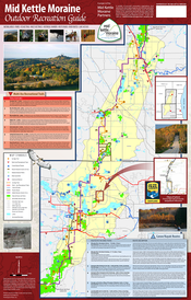
Enjoy Our Mid Kettle Moraine Outdoor Recreation Map
The Partners have designed a Recreational Asset Map of the Mid Kettle Moraine’s outstanding natural, cultural and recreational features. It can be used to plan outings in all seasons, close to home and affordable. You can show your support for this precious landscape by planning a hike, cross-country ski trek, picnic, canoe trip, or nature walk...and by spreading the word about the importance of preserving lands in the Mid Kettle Moraine Region!
|
Download the PDF MAP to your computer, tablet or phone.
To request a FREE hard copy MAP please use the Contact Form on the Contact page. |
| ||